Yatharagga: Satellite Laser Ranging (SLR) Station
| Revision as of 11:39, 3 May 2007 (edit) Paul (Talk | contribs) ← Previous diff |
Current revision (05:25, 15 May 2012) (edit) Paul (Talk | contribs) |
||
| Line 1: | Line 1: | ||
| <BR> [[Image:Moblas 5.jpg|right|thumbnail|250px|Moblas 5 site: ''Photo - NASA'']] | <BR> [[Image:Moblas 5.jpg|right|thumbnail|250px|Moblas 5 site: ''Photo - NASA'']] | ||
| - | This space station has had two names - Yarragadee and Yatharagga - and two functions - astronaut voice communications’ and ‘satellite laser ranging’.<BR> In both manifestations it was part of NASA’s '''Satellite and Data Tracking Network (STDN)''' operating as a sub-station from Orroral Valley Tracking Station, Canberra, until that closed in 1985. It now operates as part of the '''International Laser Ranging Service (ILRS)'''. | + | '''Location: 29.8 South, 115.6 East''' |
| + | |||
| + | This space station has had two names - '''Yarragadee''' and '''Yatharagga''' - and two functions - astronaut voice communications’ and ‘satellite laser ranging’. In both manifestations it was part of NASA’s '''Satellite and Data Tracking Network (STDN)''' operating as a sub-station from Orroral Valley Tracking Station, Canberra, until that closed in 1985. It now operates as part of the '''International Laser Ranging Service (ILRS)'''. | ||
| Its first name was Yarragadee space station on Yarragadee pastoral property, but when the property was divided into two parts – Yarragadee and Yatharagga – the space station ended up on the Yatharagga property. NASA however still calls the space station by its old name. The best way to describe it would be as 'the Yarragadee SLR Station on the Yatharagga property'. | Its first name was Yarragadee space station on Yarragadee pastoral property, but when the property was divided into two parts – Yarragadee and Yatharagga – the space station ended up on the Yatharagga property. NASA however still calls the space station by its old name. The best way to describe it would be as 'the Yarragadee SLR Station on the Yatharagga property'. | ||
| - | The Yarragadee space station was opened in 1975 as an out-station of the Orroral Valley Tracking station to provide a VHF astronaut voice link to support the Apollo-Soyuz mission in July 1975; filling the hole left by closure of the Carnarvon Tracking Station. A VHF quad-helix array fixed to a relocated Carnarvon AcqAid tower and antenna mount provided the link. It continued to be used for NASA’s Shuttle missions beyond the closure of Orroral Valley Tracking Station until the '''Tracking and Data Relay Satellite System (TDRSS)''' was in full operation and made the link obsolete. | + | The Yarragadee space station was opened in 1975 as an out-station of the Orroral Valley Tracking station to provide a VHF astronaut voice link to support the Apollo-Soyuz mission in July 1975; filling the hole left by closure of the Carnarvon Tracking Station. A VHF quad-helix array fixed to a relocated Carnarvon AcqAid tower and antenna mount provided the link. From 1979 onwards, it continued to be used for NASA’s Shuttle missions beyond the closure of Orroral Valley Tracking Station until the '''Tracking and Data Relay Satellite System (TDRSS)''' was in full operation and made the link obsolete. |
| ---- | ---- | ||
| - | Yarragadee was expanded to include '''Moblas 5''', a mobile '''Satellite Laser Ranging (SLR''') facility in mid 1978. | + | '''Yarragadee''' was expanded to include '''Moblas 5''', a mobile '''Satellite Laser Ranging (SLR''') facility in mid 1978. |
| [[Image:SLR system.jpg|left|thumbnail|230px|The SLR method:<BR>''Image – Geoscience Australia'']] | [[Image:SLR system.jpg|left|thumbnail|230px|The SLR method:<BR>''Image – Geoscience Australia'']] | ||
| [[Image:Laser.jpg|right|thumbnail|150px|The Mobile Laser:<BR>''Image – NASA'']] | [[Image:Laser.jpg|right|thumbnail|150px|The Mobile Laser:<BR>''Image – NASA'']] | ||
| - | '''Moblas''' is a NASA system using laser ranging to establish the relative position and velocity of a satellite and the tracking station to an accuracy of better than 1 cm with a single laser shot. A pulsed laser light source is fired at a reflecting satellite, 'echoed' by a corner reflector and then received by a powerful optical telescope fitted with low level light sensors. The prime satellite supported is '''Lageos''' (Laser Geodynamic Satellite) launched on 4 may 1976 and expected to stay in orbit for 8 million years. It is encrusted with 426 highly precise corner reflectors. | + | '''Moblas''' is a NASA system using laser ranging to establish the relative position and velocity of a satellite and the tracking station to an accuracy of better than 1 cm with a single laser shot. A pulsed laser light source is fired at a reflecting satellite, 'echoed' by a corner reflector and then received by a powerful optical telescope fitted with low level light sensors. The prime satellite supported is '''Lageos''' (Laser Geodynamic Satellite) launched on 4 May 1976 and expected to stay in orbit for 8 million years. It is encrusted with 426 highly precise corner reflectors. |
| - | The station also housed a '''Laser Protection Surveillance Radar''' to ensure that aircraft would not enter the beam of the laser transmitter. The ‘radar log’ shows the radar was operational in July 1978 but laser tracking may not have started until December ‘78. | + | The station also housed a '''Laser Protection Surveillance Radar''' to ensure that no aircraft were in the vicinity when the laser transmitter was fired. The ‘radar log’ shows the radar as operational in July 1978 but indicates that laser tracking may not have started until December ‘78. |
| - | The Yarragadee site is important because of the relative paucity of locations in the Southern Hemisphere. The primary purpose of its measurements are to help define a geo-potential field model of the Earth, the centre of its mass, the northwards drift and stability of the Australian continental plate. The process has been described as satellite positioning of Earth rather than the Earth positioning a satellite. | + | The Yarragadee site remains important because of the relative paucity of locations in the Southern Hemisphere. The primary purpose of its measurements are to help define a geo-potential field model of the Earth, the centre of its mass, and the northwards drift and stability of the Australian continental plate. The process has been described as 'satellite positioning of Earth' rather than 'Earth positioning of a satellite'. |
| The site facilities also include '''DORIS''', a European Space Agency (ESA) Doppler satellite tracking system, '''GLONASS''' a Russian Federation Global Positioning system, and a '''GPS''' facility. | The site facilities also include '''DORIS''', a European Space Agency (ESA) Doppler satellite tracking system, '''GLONASS''' a Russian Federation Global Positioning system, and a '''GPS''' facility. | ||
Current revision
Location: 29.8 South, 115.6 East
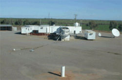
This space station has had two names - Yarragadee and Yatharagga - and two functions - astronaut voice communications’ and ‘satellite laser ranging’. In both manifestations it was part of NASA’s Satellite and Data Tracking Network (STDN) operating as a sub-station from Orroral Valley Tracking Station, Canberra, until that closed in 1985. It now operates as part of the International Laser Ranging Service (ILRS).
Its first name was Yarragadee space station on Yarragadee pastoral property, but when the property was divided into two parts – Yarragadee and Yatharagga – the space station ended up on the Yatharagga property. NASA however still calls the space station by its old name. The best way to describe it would be as 'the Yarragadee SLR Station on the Yatharagga property'.
The Yarragadee space station was opened in 1975 as an out-station of the Orroral Valley Tracking station to provide a VHF astronaut voice link to support the Apollo-Soyuz mission in July 1975; filling the hole left by closure of the Carnarvon Tracking Station. A VHF quad-helix array fixed to a relocated Carnarvon AcqAid tower and antenna mount provided the link. From 1979 onwards, it continued to be used for NASA’s Shuttle missions beyond the closure of Orroral Valley Tracking Station until the Tracking and Data Relay Satellite System (TDRSS) was in full operation and made the link obsolete.
Yarragadee was expanded to include Moblas 5, a mobile Satellite Laser Ranging (SLR) facility in mid 1978.
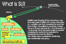
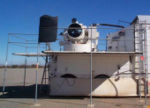
Moblas is a NASA system using laser ranging to establish the relative position and velocity of a satellite and the tracking station to an accuracy of better than 1 cm with a single laser shot. A pulsed laser light source is fired at a reflecting satellite, 'echoed' by a corner reflector and then received by a powerful optical telescope fitted with low level light sensors. The prime satellite supported is Lageos (Laser Geodynamic Satellite) launched on 4 May 1976 and expected to stay in orbit for 8 million years. It is encrusted with 426 highly precise corner reflectors.
The station also housed a Laser Protection Surveillance Radar to ensure that no aircraft were in the vicinity when the laser transmitter was fired. The ‘radar log’ shows the radar as operational in July 1978 but indicates that laser tracking may not have started until December ‘78.
The Yarragadee site remains important because of the relative paucity of locations in the Southern Hemisphere. The primary purpose of its measurements are to help define a geo-potential field model of the Earth, the centre of its mass, and the northwards drift and stability of the Australian continental plate. The process has been described as 'satellite positioning of Earth' rather than 'Earth positioning of a satellite'.
The site facilities also include DORIS, a European Space Agency (ESA) Doppler satellite tracking system, GLONASS a Russian Federation Global Positioning system, and a GPS facility.
For more information see:
http://envisat.esa.int/instruments/doris/ for the DORIS system; and
http://www.ga.gov.au/geodesy/gps/gpsoverview.jsp for GPS and GLONASS systems.
Return to WA in Space
Thanks to Trevor Mosel and Stan Parkes for their help in defining the various dates in this account, and to Soula Veyrader for access to the surveillance radar records held by Melville City Council, Perth.


